What the Narrows Actually Is
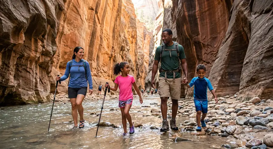
The Zion Narrows is a 16-mile stretch of the Virgin River canyon where the walls close to as narrow as 20 feet and tower 1,000 feet overhead. You're not hiking on a trail, you're walking in the river. Ankle-deep in summer. Thigh-deep in spring. The bottom-up route from the Temple of Sinawava starts on a paved riverside walk and then puts you in the water for as far as you want to go. Most day hikers turn around at Wall Street, about 4 miles in. The top-down route is a 16-mile permit-required overnight through Zion Slot Canyon from Chamberlain Ranch.
This is Zion's most iconic hike and, on a summer weekend, it shows. The Temple of Sinawava parking area fills by 7am. The Narrows gets crowded enough that you'll sometimes be stuck waiting behind a slow group with nowhere to pass. Go early, go on a weekday, or go in shoulder season, the canyon is a different experience in October than in July.
Trail Stats
- Bottom-up day hike: Up to 9.4 miles round trip (most people do 5–8 miles), ~350 ft elevation gain, 4–7 hours
- Top-down overnight: 16 miles one-way, 1,200 ft elevation loss, permit required
- Difficulty: Moderate, the river walking is tiring in a way flat terrain isn't
- Best season: Late May through October (spring snowmelt = high water; July–August = flash flood season)
- Permits: Bottom-up day hike = no permit. Top-down = permit required (Zion lottery)
Bottom-Up Day Hike: The Approach
The bottom-up Narrows starts at the end of the Riverside Walk, a 1-mile paved trail from the Temple of Sinawava shuttle stop. Take the Zion Canyon Shuttle to the last stop, you can't drive to this trailhead between late March and early November. The shuttle runs frequently and the ride from the visitor center takes about 45 minutes with stops.
At the end of the Riverside Walk, you'll see the Virgin River and no defined trail. That's intentional. Wade in. The riverbed is slick sandstone with loose cobbles, footing is genuinely tricky on wet rock. The water is cold year-round: expect 60–68°F in summer, colder in spring and fall. Current can be moderate to strong after rain.
What You'll See Mile by Mile
Miles 0–1 (Riverside Walk to canyon entry): Paved, easy, stunning views of the canyon opening. Lots of people. Ends where the water begins.
Miles 1–2 (canyon entry to Mystery Canyon): First mile of wading. The walls start closing in. You'll pass Orderville Canyon on the right, a beautiful slot worth a quick detour. Mystery Canyon rappels in from the left. Water is typically knee-deep here.
Miles 2–4 (Wall Street): This is the money section. The walls narrow to 20–30 feet, the light turns deep violet at midday, and the river deepens. Expect waist-deep crossings in spots. Most day hikers turn around here, it's enough for a full day.
Miles 4–9 (Deep Creek confluence and beyond): Past Wall Street the crowds thin dramatically. You'll reach the Deep Creek confluence where the river volume roughly doubles, flow becomes faster and harder to wade. Big Springs at mile 9.5 is where top-down hikers spend the night and where most day hikers stop.
Gear: What You Actually Need
Canyoneering rental shops just outside the park (Zion Outfitter, Zion Adventure Company) rent the essential kit: neoprene socks, canyoneering shoes with sticky rubber soles, and a walking stick or trekking poles. This gear makes an enormous difference. Regular hiking boots on wet sandstone are slippery. Neoprene socks keep your feet warm enough to hike all day in cold water.
Rent or bring: neoprene socks ($5–8/day to rent), canyoneering shoes or water sandals with grip, trekking poles or a walking stick, dry bag for your pack, and a waterproof or water-resistant jacket if rain is possible.
Do not attempt the Narrows in flip-flops or Crocs. Slips and ankle rolls are common and the uneven riverbed will catch any shoe without proper ankle support.
Flash Flood Risk: The Real Hazard
Flash floods in the Narrows are not theoretical. In 2015, a wall of water swept through and killed hikers. The canyon drains a 2,000-square-mile watershed, a thunderstorm 50 miles away in Nevada can send a flood through Zion while the sky above you is blue.
The park posts a daily flash flood risk rating at the visitor center and online. Do not enter the Narrows when the risk is high or if thunderstorms are forecast in the region. Zion will close the Narrows when risk warrants it, check the NPS website the morning of your hike.
Warning signs: roaring or rumbling sound, sudden increase in water turbidity (water turns brown), rising water level, smell of mud. If you see or hear any of these, climb as high as possible immediately. Don't wait to confirm.
Top-Down Permit Hike: Chamberlain Ranch to Temple of Sinawava
The top-down route is a completely different experience. You start at Chamberlain Ranch on the eastern edge of the park and hike 16 miles downstream to the Temple of Sinawava, with the current, not against it. The permit is required and competitive: apply through the Zion lottery at recreation.gov, typically in March for the following permit season.
The top-down requires: two cars (or a shuttle), a permit, a dry suit or wetsuit in cold conditions, and canyon navigation skills. Several sections require swimming. You camp at Big Springs (mile 9.5), the only legal camping area. The permit specifies your entry date and campsite.
This is a serious undertaking. Hypothermia risk is real in spring. Flash floods are more dangerous top-down because there's nowhere to get out quickly. Go with experienced people or a guide the first time.
When to Go
June–September: Warmest water, highest crowds, highest flash flood risk. July and August are statistically the riskiest months for flash floods, afternoon thunderstorms are common. Early June before the summer rush and late September are the sweet spots.
October–November: Crowds drop dramatically. Water is cold but the canyon is stunning in fall light. Fewer flash flood events. Neoprene socks go from optional to essential.
December–March: The Narrows may close entirely due to high water or ice. Call ahead. If it's open, you'll often have it mostly to yourself, but dress for hypothermia risk.
April–May: Spring snowmelt means high water, fast current, and potential closures. The park posts daily water conditions. Some years this month range is fine; other years it's waist-to-chest-deep with strong current.
Parking and Getting There
The park entrance is 3 miles from Springdale, UT on UT-9. From Las Vegas: 2.5 hours northeast. From Salt Lake City: 4.5 hours south. Do not drive into Zion Canyon between late March and early November, the road is shuttle-only. Park at the visitor center or in Springdale and take the free shuttle. Parking at the visitor center is free but fills by 8am on summer weekends. Arrive by 7am or take the Springdale town shuttle from Main Street.
Camping Near the Narrows
Watchman Campground is the only campground inside Zion Canyon, a few miles from the shuttle stop. Reserve far in advance at recreation.gov, it books out months ahead for peak season. South Campground is first-come, first-served but also fills early. Outside the park, Springdale has private campgrounds and RV parks. Primitive camping exists on BLM land outside the park boundary.